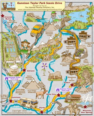
Taylor River
Taylor River has 12 miles above the reservoir and 18 Miles below it to the confluence with the East River.
Making its headwaters high up in the Rockies amongst numerous “14’ers”, the Taylor descends from the high country before emptying into the Taylor Reservoir.
Taylor River, Gunnison County, Colorado, United States (38.66361 -106.84715 38.99752 -106.56201)
Elevations: Upper= At, Reservoir 9,332, lower= 9,170 and confluence= 8,500
From the Reservoir the Taylor makes its way through Taylor Canyon for about 20 miles before meeting the East River to form the Gunnison River near the town of Almont.
Public areas are below the Reservoir/ Dam. There is a protected / no fishing area around 400 yards below the dam and then numerous marked areas between the Dam and Almont.
Alternate titles: Numerous tributaries can be fished, but well known ones are:
- Spring Creek
- Spring Creek Reservoir
- Suitable Activities: Fly Fishing
- Seasons: Year-round
- Weather: View weather forecast
- Length: 30.0 mi
- 9,350 ft
-
Land Manager:
U.S. Forest Service
Gunnison Ranger District (GMUG)
- Parking Permit Required: USFS Permits & Passes
- Recommended Party Size: 10
- Maximum Party Size: 10
- Maximum Route/Place Capacity: 10
This is a list of titles that represent the variations of trips you can take at this route/place. This includes side trips, extensions and peak combinations. Not seeing a title that fits your trip? Log in and send us updates, images, or resources.
- Taylor River - Spring Creek Reservoir
- Taylor River - Spring Creek
There are no resources for this route/place. Log in and send us updates, images, or resources.
