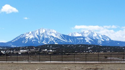
West Spanish Peak
West Spanish Peak (13,626') is located in the San Isabel National Forest and the Spanish Peaks Wilderness, near the Town of La Veta, Colorado, on the border between Huerfano and Las Animas counties.
This 7.9-mile out-and-back trail near La Veta, Colorado. Generally considered a challenging route.
Location - west spanish peak trailhead - Google Maps
- Suitable Activities: Hiking
- Seasons: May, June, July, August, September, October
- Weather: View weather forecast
- View avalanche forecast.
- Difficulty: Difficult
- Length: 7.9 mi
- Elevation Gain: 2,624 ft
- 13,583 ft
-
Land Manager:
U.S. Forest Service
Spanish Peaks Wilderness Area, San Carlos Ranger District (PSINF)
- Parking Permit Required: USFS Permits & Passes
- Recommended Party Size: 12
- Maximum Party Size: 12
- Maximum Route/Place Capacity: 12
This is a list of titles that represent the variations of trips you can take at this route/place. This includes side trips, extensions and peak combinations. Not seeing a title that fits your trip? Log in and send us updates, images, or resources.
- West Spanish Peak (13,626) and East Spanish Peak (12,688 feet) The TH for West Spanish Peak is Cordova Summit TH (37.34859079348246, -105.02431944907539) and the TH for East Spanish Peak is at 37.398490, -104.974650
There are no resources for this route/place. Log in and send us updates, images, or resources.
