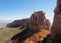
Located just outside of Grand Junction, Colorado National Monument was founded over 110 years ago, allowing the area to receive federal protection and funding. Resting on Ute lands, this protected area is home to stunning rock formations, wildlife, and exquisite skylines you can't see in the city.
In the forthcoming guidebook, Guide to Western National Monuments, readers can learn about the recent history of landmarks like these, how to get the most out of your visit, and best practices for visiting protected areas.
Enjoy a free chapter from our newest guidebook by Mike Endres. Pre-order your copy of this highly anticipated guidebook at the link below!
************************************************************************************************
THE MONUMENT: Colorado National Monument was established on May 24, 1911, by President William Taft. It is a brilliantly colored, 32-mile landscape of twisting canyons and towering sandstone formations. Over a billion years of geological history can be witnessed from its canyon rims.
The monument rises from 4,000 feet to nearly 7,000 feet in a semi-desert climatic region in western Colorado. Pine and Utah juniper are the most common trees while sagebrush, rabbitbrush, cacti, and yucca can be found in abundance. About 110 flowering plants species have been identified within the monument, most blooming in the wetter spring and fall seasons. Birds here include ravens, chukar, Gambel's quail, canyon wrens, and over 60 other species. The National Audubon Society identified the monument as an Important Bird Area in 2000. Mammals range from the antelope ground squirrel to desert bighorns and mountain lions. Numerous reptiles and amphibians also inhabit the monument.
Temperatures range from the 30s in winter to the 90s during the summer. Nights are generally cool and comfortable, except in the winter when temperatures can drop into the teens. Rain amounts to a scant 9 inches annually, falling mostly during the spring and fall seasons. Surprisingly, there is an average of 20 inches of snowfall annually.
THINGS TO DO: The 23-mile Rim Rock Drive traverses the monument from a high vantage with numerous pullouts that offer stunning vistas of the landscape below. A number of trails, ranging from 0.25 mile to 8.5 miles, offer a more intimate and adventurous way to experience the monument. A popular trail is the Monument Canyon Trail, which travels into the depths of the main canyon with views of soaring towers and possibly desert bighorn sheep. This is an 11-mile out-and-back trail of moderate difficulty, gaining 1,500 feet if you follow it to the end. This trail starts at a parking area 0.25 mile off Broadway on the east side of the monument. Even though it looks as if you're driving into someone's backyard, just keep going and you'll reach the obvious trailhead sign. Otto's Trail, 0.7-mile, is an easy out-and-back hike from the canyon rim to an overlook with grand views of the canyon and several large towers, including Independence Monument. It starts about 1.0 mile east of the visitor center on Rim Rock Drive.
Rock climbing is permitted in the monument, but climbers should check in at the visitor center first. There is an annual ascent of Independence Tower every Fourth of July to commemorate both our nation's day of independence and the first ascent by John Otto in 1911. Otto's Route, the classic route up the west side of Independence Tower, goes at 5.9 with two cruxes. One is on the second pitch, an awkward off-width, and the second is the final, airy pitch that struggles up the exposed caprock to the summit. Bike riding is popular, particularly along Rim Rock Drive, but is not permitted on trails or off-road. With adequate snow, cross-country skiing is also a common and enjoyable activity within the monument.
THINGS TO SEE: The Monument has a considerable variety of wildlife and plant life, given its austere setting. Pinyon pine and Utah juniper are easily found along the higher elevations, while the Rio Grande cottonwood and single-leaf ash are more common in the lower, wetter areas. Here you'll also find many of the sixty-three breeding bird species that call the monument home. Several of the raptor species can be seen along the high sandstone walls. The visitor center has a checklist for birds and a log of recent sightings.
GETTING THERE: From Fruita, take Exit 19 off I-70 and drive 4.0 miles to the West Entrance.
From the center of Grand Junction, take Broadway, which becomes Monument Road, approximately 4 miles to the East Entrance.
FACILITIES: Camping is available year-round within the monument, which has fifty-one sites at the Saddlehorn Campground near the visitor center. While suitable for both tents and RVs up to 40 feet, there are no electric hookups or showers. A-Loop sites are available on a first-come, first-served basis while B-Loop sites can be reserved up to six months in advance at recreation.gov. All sites offer a table, charcoal grill, restrooms, and drinking water. Backcountry camping is allowed anywhere within the monument at least 0.25 mile away from the road and 150 feet from trails. Water is not readily available in the backcountry; you must carry your own. At least one gallon per person per day in the summer months is recommended. Wood fires are not permitted anywhere within the monument. The towns of Fruita and Grand Junction are nearby.
*******
To learn more about national monuments in the Western United States and start planning your epic road trip, order your copy of Guide to Western National Monuments here.
 CMC Press

Add a comment
Log in to add comments.BPX Camping Trip to CNM upcoming October 11-14, 2022.