Trip
Hiking – Dry Gulch TH to Mt Bethel
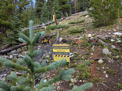
This EXPLORATORY hike to the Wichita State plane crash site near Silver Plume, Colorado, follows a steep, rugged route through forest and alpine terrain to a somber memorial honoring the victims of the 1970 tragedy. We can explore scattered wreckage and a plaque at the crash site. For those seeking a more challenging adventure, an optional scramble to Mount Bethel’s summit offers sweeping views of the Front Range and I-70 corridor. This is the third hike in the series of hikes to visit plane crash sites.
- Sun, Aug 31, 2025
- Bobcats Section
- Hiking
- Adults
- Difficult, off-trail
- Challenging
- Mileage: 6.0 mi
- Elevation Gain: 2,700 ft
- High Point Elevation: 12,700 ft
- Pace: 1.3-1.8 MPH
- FULL, 4 on waitlist (6 capacity)
- 1 (2 capacity)
- Cancellation & Refund Policy
This EXPLORATORY hike starts use off I-10 near Silver Plume. The route follows an access road for about 1 mile then diverges from established routes, following a faint, unofficial trail through lodgepole pine forest and steep alpine terrain. After about 1.7 miles and 600 feet of elevation gain, we’ll reach the somber site of the 1970 Wichita State University plane crash, where a twin-engine charter carrying members of the football team tragically impacted the mountainside. The area is marked by a commemorative plaque, with visible debris scattered across the slope, offering a powerful moment of reflection amid the quiet, remote landscape. We’ll have the options of continuing to the summit of Mount Bethel. As we ascend to the summit, our route will take us past a series of large snow fences designed to control avalanches. The 12,705-foot summit provides us with views of the Front Range, Loveland Pass, and the distant Continental Divide. We’ll find a comfortable spot for lunch/snack. We will make our way back the the trail following the same route. Our pace will be consistent with completing this hike in a reasonable amount of time. Overall ~6 miles and ~2700 ft elevation gain. (Wichita State Plane Crash Site - CalTopo)
The Bobcats’ mission is to ensure a variety of adventurous CMC trips, mostly on weekdays, all year long. Our trips tend to be faster-paced, on more challenging routes, and with fewer stops. We foster a strong community of hikers seeking challenge, discovery, and camaraderie. You can search the CMC Calendar for Bobcat trips any time by selecting “Bobcats Section” in the CMC Trip Calendar “Section pull-down menu. To join our free mailing list and become a member, select the Bobcats Section anytime in your Member Profile. (Bobcats Section — The Colorado Mountain Club)
Carpool Place & Time: Meet at the Wooly Mammoth PnR (Section BB) at 7:00AM, for a 7:15AM departure (Wooly Mammoth Park-N-Ride - Google Maps)
We'll carpool to the Trailhead Parking, across I-70 from Loveland Ski area (39°41'09.0"N 105°53'10.8"W - Google Maps)
Required Equipment
Ten essentials are required. Trekking poles are recommended.
