Trip
Hiking – RMNP - Longs Peak TH - Storm Peak
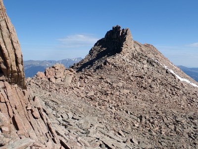
A hike to Storm Peak from the Longs Peak TH in RMNP. Storm Peak is the peak immediately to the west when you’re making your way through the Boulder Field on the way to the Keyhole and Longs Peak.
- Fri, Sep 12, 2025
- Bobcats Section
- Hiking
- Adults
- Difficult
- Difficult
- Mileage: 12.5 mi
- Elevation Gain: 3,950 ft
- High Point Elevation: 13,321 ft
- Pace: Moderate (1.8 - 2.0 avg moving speed)
- FULL, 5 on waitlist (8 capacity)
- Cancellation & Refund Policy
Storm Peak is the peak immediately to the west when you’re making your way through the Boulder Field on the way to the Keyhole and Longs Peak in RMNP. This is considered a difficult hike because it is relatively long and has a lot of elevation gain. Technically, according to the Summitpost writeup linked below, Storm Peak is a relatively easy mountain. Considering a good, well-maintained class-1 trail exists to within a quarter mile of its summit followed by an easy class-2 scramble
Here's a link to the “Storm Peak” writeup in Summit Post: https://www.summitpost.org/storm-peak/151406
Meet in the Safeway parking lot at 3325 28th Street in Boulder at 5:30am so we can form carpools and leave no later than 5:40am. Specifically, park in the north end of the Safeway parking lot, near the Phillips 66 gas station. Here’s a Google Maps link to the Safeway: https://maps.app.goo.gl/mpG84vtWp2eCEGxU8
An alternative meeting location for those living further north is to meet at Sandstone Park in Lyons, parking on the Railroad Avenue side (south side) of the park, at 6:00am. Here’s a Google Maps link to the Lyons meeting place: https://maps.app.goo.gl/s5CfGVLuKXDVLWCa7
The Longs Peak Trailhead is off the Peak-to-Peak, Hwy 10 miles south of Estes Park, 7 miles north of Allenspark. Here’s a Google Maps Link to it: https://maps.app.goo.gl/rvYGcnzPWJqSgRX16
Required Equipment
Bring your 10 essentials
