BPX 2-Day: Lake Ann from South Fork Clear Creek / Huron Peak TH
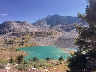
Deep in the Collegiate West route of the Colorado Trail is an incredible alpine lake sitting below a pass with unsurpassable views! With views of Huron Peak and Three Apostles on the way up, this moderate out-and-back to Lake Ann allows for an early summit of nearby Lake Ann Pass on Day 2 before heading back to the trailhead.
Suggested Backpacking Section (BPX) itinerary for 2-day trip to be used for CMC trips
led by BPX leaders for BPX members.
Day 1: Meet up and carpool to the South Fork Clear Creek /Huron Peak TH. Note, this is a 3 hour drive from Denver, the last 40 minutes on a dirt road. It is generally passable for most vehicles in summer. Hike the Lake Ann Trail (#1462) / Colorado Trail - Collegiate West (#1776) about 3 miles to just below Lake Ann. Lake Ann is above tree line. There are creeks and campsites in the wooded area here, over a range of about a half mile. Find a good site and make camp. If the weather is clear, enjoy an optional afternoon hike up to the lake, which is stunning and worthy of exploration and camera gear. (~3.1 miles, +1,097 ft.).
Day Hike Route: Lake Ann (0.6 miles, +-222 ft.)
Day 2: Hike south on Lake Ann Trail (#1462) past the lake and ascend Lake Ann Pass, a steep trail with some loose scree sections. NOTE: You will be above tree line for this side hike. Hike .9 mile to the top of the pass, pausing to take photos along the way. The top of the pass sits at 12.6K feet and there are amazing views, especially back to the north of Lake Ann and the Three Apostles. Hike back down and break camp, then hike back to the trailhead (3.1 miles, +41 / -1,113 ft.).
Day Hike Route: Lake Ann Pass (1.9 miles, +-921 ft.)
Overall Route (with side hikes): 8.4 miles, +-2,126 ft.
NOTES:
- Always practice Leave No Trace techniques.
-
More information about Collegiate Peaks Wilderness is available here.
-
This camp is at high altitude (over 11.5K feet) and the side hikes are above tree line and at high altitude, with the pass topping out at 12.6K feet
- The trail above the lake to the top of the pass is steep, narrow, and there is some loose scree and a talus section. Trekking poles recommended. For hikers who are sensitive to exposure, it might not be a great fit, but the exposure is not ledge-like--it's just very high and open!
- Driving Directions: From the Colorado Mountain Club (Golden, CO) to the South Fork Clear Creek /Huron Peak TH.
- Suitable Activities: Backpacking
- Seasons: July, August, September
- Weather: View weather forecast
- Difficulty: Moderate
- Length: 8.4 mi
- Elevation Gain: 2,126 ft
- 12,594 ft
-
Land Manager:
U.S. Forest Service
Collegiate Peaks Wilderness Area, Leadville Ranger District (PSINF)
- Parking Permit Required: USFS Permits & Passes
- Recommended Party Size: 6
- Maximum Party Size: 12
- Maximum Route/Place Capacity: 12
There are no resources for this route/place. Log in and send us updates, images, or resources.
