Field trip: TCS Glacier Travel
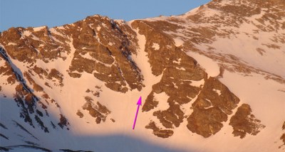
Field Day 1 – Gray's Peak - Torrey's Peak TH - Gray's Peak - Lost Rat Couloir
Technical Trip Leader lead climb- Couloir climb up lost rat to the summit of grays peak from either the lower or upper TH
- Sun, May 14, 2023
- CMC State
- Mountaineering
- Intermediate Alpine Climb
- Adults
- Moderately Difficult Class D, Challenging
- Challenging
- Mileage: 7.3 mi
- Elevation Gain: 3,000 ft
- High Point Elevation: 14,278 ft
- Pace: 1,000 ft/hr
- 6 (5 capacity)
- Cancellation & Refund Policy
Gray's Peak - Lost Rat Couloir Information
Route Plan
From the summer trailhead, cross the bridge that spans the stream in Stevens Gulch and follow the well-defined Grays trail up the hill into Stevens Gulch. Continue on the Grays trail for nearly 1.5 miles until you are near the trail sign near 12,100'. Just before the sign, locate a small road that leaves the left side of the Grays trail. Follow the small road down a bit and then south towards the center of the basin. After heading south for a bit, continue on the road as you approach the southwest end of the basin. Stay on or near the road as it climbs onto the talus below Lost Rat. Hike over to the base of the couloir. Crampons, axe, helmet, and avalanche gear are recommended.
Start climbing. Above 12,800', the terrain steepens as you approach the confines of the couloir. Above 13,100', reach a fork in the couloir. Stay left and continue up the main couloir. The next 300 feet is straightforward and the slope angle reaches 45 degrees, avg is 40 degrees. Near 13,500', the couloir turns slightly left as you pass through the narrowest section. Climb the last 100 feet to reach the top of Lost Rat. Turn right (west) to see the remaining 700 feet up Grays' east ridge. The couloir melts out at the top so be prepared for a scree finish. Follow the ridge to the summit. Return on the standard Grays trail.
“Moderate to easy angled snow. Lots of rock fall. when you get to the Y, 3/4's way up, stay to your left and top out on the ridge which leads to summit of Grays. There is 800 ft of good snow climbing. Usually a cornice at the top. The couloir melts out at the top so be prepared for a scree finish.” - https://www.summitpost.org/lost-rat-couloir/155950
The road to the upper 4WD TH of Grays Peak may or may not be accessible at this time of year. If it is, we can shuttle everyone to the top, if not we will hike the 3 mile one way road.
Road to upper 4WD TH:
- Low angle 3 mile road with ~1500ft of gain
4WD TH to base of couloir:
- ~2.2 miles
- ~1490 feet of gain
- Depending on how loaded the eastern slopes of Kelso Mountain are, we may need to give it some room by hanging hikers left closer to the creek bed
Base of couloir to top
- ~.30 miles from base of couloir to top of couloir
- ~900 feet of gain
- Usually a cornice at the top
Couloir to summit
- ~.40 miles to summit
- ~680 feet of gain
- Take crampons off at top of couloir to hike the rest of this
- Descend standard route of Grays
Start Time: Meet at TH 3:30 AM, hike by 4:00 AM MDT - 2023.05.14
Trailhead
- Grays Peak Trailhead
- Google Maps
- 2 E Bakerville Rd, Silver Plume, CO 80476
we can also car pool from woolly mammoth
Required Equipment
- 10 essentials
- Avy, Beacon, Probe
- Snowshoes (mandatory, unfortunately)
- Ice axe
- Crampons
- Helmet
- Harness
- 4 locking carabiners minimum
- Belay device (ATC)
- Autoblock, waist and foot prusiks, 2 double length runners
Weather/Avy Forecast
