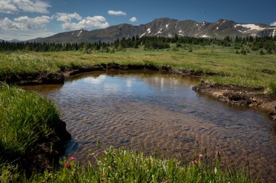
BPX 2-Day: Native Lake from Native Lake TH
A moderate two day, one night backpack to camping by Native Lake. 7.6 miles and 1,100 vertical feet total.
Suggested Backpacking Section (BPX) itinerary for 2-day trip to be used for CMC trips led by BPX leaders for BPX members:
Day 1: Starting at the Native Lake TH, hike south on the Native Lake Trail (#1489) to the area around Native Lake where we will find campsites. Explore the area, camp, stay the night (3.75 miles, +1,151 / -672 ft.).
Day 2: Have breakfast, pack up, hike out to cars and return to Denver (3.75 miles, +672 / -1,151 ft.).
Overall Route: 7.6 miles, +-1,824 ft.
NOTES:
- Always practice Leave No Trace techniques.
- More information about Mount Massive Wilderness is available here.
- Driving Directions: Take I-70 West to Exit 195 - Leadville which is CO Hwy 91 S. Continue on Hwy 91 S for approx. 22 miles. Right turn to US 24 W for 1.7 miles to CR 99 for 1.6 miles to CR 9 for 0.4 miles. Turn Right onto CR 9D for 0.8 miles, Turn Right onto CR 4 for 4.3 miles, continue straight onto Hageman Pass Rd 3.5 miles to TH.
- Google Map Driving Directions: From the Colorado Mountain Club (Golden, CO) to the Native Lake TH.
- Suitable Activities: Backpacking
- Seasons: June, July, August
- Weather: View weather forecast
- Difficulty: Moderate
- Length: 7.6 mi
- Elevation Gain: 1,824 ft
- 11,860 ft
-
Land Manager:
U.S. Forest Service
Mount Massive Wilderness Area, South Platte Ranger District (PSINF)
- Parking Permit Required: USFS Permits & Passes
- Recommended Party Size: 6
- Maximum Party Size: 12
- Maximum Route/Place Capacity: 12
- Trails Illustrated 104
There are no resources for this route/place. Log in and send us updates, images, or resources.
